

MLPA Facts and Maps

Marine protected areas (MPAs) are a simple and urgently needed way to ensure future generations will inherit the same incredible coastal resources we have enjoyed.
In a landmark decision, the California Fish and Game Commission (FGC) voted to adopt a network of marine protected areas (MPAs) that stretches from Santa Barbara to the U.S.–Mexico border. The new MPAs build on protections adopted at the northern Channel Islands in 2003 and constitute the southern portion of the statewide underwater park system envisioned by California’s Marine Life Protection Act of 1999. The approved plan was a compromise based on input from fishermen, divers, conservationists, and scientists. The south coast is an iconic landscape, including eight offshore islands, the Palos Verdes Peninsula, Orange County’s coves and headlands, the coastline of the Santa Monica Mountains State Recreation Area, Point Mugu State beach, and Malibu.
But the idyllic surface of our coastal waters masks growing problems. Over time, we have seen our marine environment steadily decline as a result of unwise coastal development, urban runoff, and overuse. These pressures have reduced the bounty of Southern California’s waters to a fraction of what our grandfathers knew.
Marine protected areas (MPAs) are a simple and urgently needed way to ensure future generations will inherit the same incredible coastal resources we have enjoyed. Like “underwater parks”, they preserve sensitive plants and animals while allowing people to experience a healthier marine environment. MPAs and reserves are scientifically monitored and evaluated by state and local marine scientists for their effectiveness.
With the December 15, 2010 decision by the Fish and Game Commission, Marine Protected Areas now cover about 15% of Southern California’s state waters. About 12% are fully no-take (state marine reserves and no-take conservation areas). The new MPAs took effect on January 1, 2012.
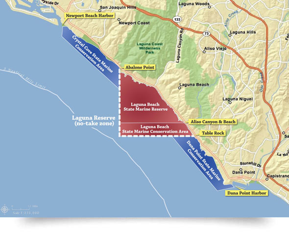
See maps of all of California’s Marine Protected Areas Below is a map showing Laguna’s marine protected areas.
Friend’s Corner
We are honored that Sylvia Earle would enthusiastically wear a "Reserve Laguna" button to indicate her support for our efforts.
She has been called "Her Deepness" by the New Yorker and the New York Times, "Living Legend" by the Library of Congress, and the first "Hero for the Planet," is an oceanographer, explorer, author...Learn More

Contact Us · Donate · Get our newsletter · All Pages
© 2011–2026 Laguna Bluebelt Coalition. All rights reserved.
