


Letter to the Fish and Game Commission, November 17, 2026

November 17, 2026
President Sklar, Vice President Anderson, Commissioner Hostler-Carmesin, Commissioner Murray, and Commissioner Zavaleta
California Fish and Game Commission
P.O. Box 944209, Sacramento, CA 94244-2090
Via email: fgc@fgc.ca.gov
cc: Melissa Miller-Henson, Executive Director
Re: Petition 2023-24MPA_AM1 (Laguna Beach SMCA and Dana Point SMCA): concerns about the review process and recommendations for future petitions
Dear President Sklar and Commissioners,
Thank you for your attention to Petition 2023-24MPA_AM1 and for the kind words several of you offered at the October 16, 2026, meeting. After careful consideration, the Laguna Bluebelt Coalition has decided not to request reconsideration of the Commission’s decision.
We are writing because we have serious concerns about how our petition was evaluated, and because we believe the lessons of this process can strengthen adaptive management of California’s MPA network. We offer these concerns in good faith, and we remain committed to working with the Commission, the Department, and the Ocean Protection Council in the years ahead.
Our concerns
1. Boundary details should be settled in rulemaking, not used as a reason to deny. At the October 16 meeting, staff acknowledged that a mapping error did not greatly influence the recommendation, which was based primarily on biology, and noted that exact boundaries are refined by the Department during rulemaking. Yet at least one Commissioner cited concern that changing the boundary could cause confusion and enforcement challenges. If boundary details can be refined in rulemaking, they should not be a reason to deny a petition before rulemaking begins. We ask the Commission to distinguish between boundary concerns that can be resolved during rulemaking and decisions that justify using an incorrect boundary to deny the petition.
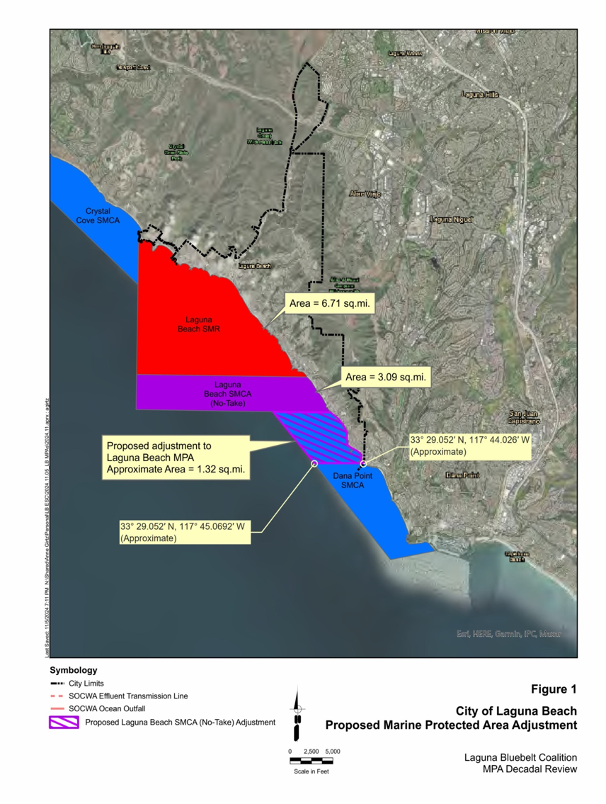
2. The Department’s main public map of our proposal is outdated. The main StoryMap page for this petition, the Department’s primary public source for our proposal, still shows the southern boundary as originally submitted, drawn as a diagonal line. Our amended boundary to facilitate enforcement, which follows the east-west latitude line at 33°29.052′ N from the shore at 117°44.026′ W to 117°45.069′ W offshore, as shown on the map attached to our March 2025 amended petition, appears only on a separate page (see attachment). At the October 16 meeting, staff acknowledged that at least one StoryMap map had not been updated; as of November 14, 2026, the main page still shows the original line. A petition should be evaluated, and presented accurately to the public, as amended.
3. The agencies acknowledged real conservation benefits but did not explain how they were weighed. The Department and OPC both acknowledged that the extension would increase protection and could benefit fish species throughout the MPA Network. The Department’s evaluation found 0.36 square miles of currently unprotected kelp habitat and increases of 45% in protected total area, 321% for rocky intertidal, and 176% overall beach habitat. It also acknowledged that anchor drag and other fishing activity may damage the rocky reef. We ask for a clearer explanation of how these acknowledged benefits were weighed against the concerns supporting denial.
4. The persistent differences among nearby reefs warrant further investigation. The 2014–2016 heatwave affected the entire coast. Reef Check’s February 2026 report found stable giant kelp densities inside the nearby Laguna Beach reserve, higher than at Thousand Steps and Three Arch Bay, while satellite data show Thousand Steps has remained near zero canopy for more than a decade. These observations do not by themselves establish the cause of the difference, but a regional event alone does not explain why reefs a short distance apart have followed such different paths. That question deserves a fuller explanation, including whether local fishing pressures may be slowing recovery.
5. “Original intent” should not foreclose adaptive management. We recognize the importance of the original planning agreements. The Department cited conflict with the original intent of the MLPA planning process and with a fishing ground deliberately left open. The MLPA calls for adaptive management in response to new information (Fish and Game Code §2852). If any change to boundaries negotiated more than a decade ago conflicts with original intent, few adaptive management petitions can succeed. We ask the Commission to clarify how these two principles are to be weighed.
6. The process placed a heavy burden on volunteers. From submission in December 2023 to decision in October 2026, our all-volunteer coalition prepared reports, analyses, and testimony over nearly three years, and a large number of residents attended and testified at the May 19, 2026 regional meeting in San Clemente. That public investment deserves a final analysis that responds to the record as it stood at decision time.
Our recommendations
We respectfully recommend the following for future MPA petitions:
- Provide a brief written update when key objections are found to be mistaken or new evidence arrives. When staff acknowledge that a central objection was mistaken, or when significant new evidence arrives after the Department’s evaluation, a brief written update should be provided before the Commission acts. We recognize that staff capacity is limited. This need not be a full re-evaluation: a short memo stating whether the new information changes the recommendation, and why, would give the Commission, the petitioner, and the public a clear basis for the decision.
- Let petitioners verify maps before evaluations are published. A brief check that maps and coordinates match the petition would prevent the public from being shown boundaries a petitioner did not request. We also ask that the Department share with petitioners the GIS boundary files used in its evaluation, so the line analyzed can be compared with the line proposed.
- Publish how “original intent” is weighed against adaptive management. Clear criteria would tell future petitioners what kind of evidence can justify changing a boundary set during the original planning process. Socioeconomic impacts require site specific transparent, verifiable data.
- Monitor unprotected reefs next to MPAs. Sites such as Thousand Steps and Three Arch Bay offer natural comparisons with adjacent reserves. We ask that the next Decadal Management Review include such sites, and we encourage collaboration with Reef Check and other partners.
- Set a clear path for petitions between ten-year reviews. Petitioners and the public would benefit from a published timeline for when and how adaptive management petitions can next be submitted.
Looking ahead
At the October 16 meeting, Commissioner Zavaleta urged that all tools be considered together to support kelp forests, including more precise measures such as species-specific fishing regulations and restoration. Laguna Beach’s Environmental Sustainability Committee likewise recommended further independent science, outreach to the fishing community, and exploring stewardship models for this coastline. We take that guidance seriously.
Between now and the next Decadal Management Review, we intend to explore near-term measures: a petition on California sheephead fishing rules that would protect the large fish most important to urchin control, continued reef monitoring with Reef Check, kelp restoration, and conversations with local fishers. We would welcome guidance from the Commission and the Department on which pathways they would find most constructive.
The reefs at Thousand Steps and Three Arch Bay remain among the most important, unprotected kelp habitat on the Orange County coast. We will continue to gather data, work with our partners, and return to the Commission with a stronger record when the next opportunity comes.
Thank you for your service and for considering these concerns and recommendations. We would welcome the chance to discuss them with Commission staff.
Respectfully,
Mike Beanan, Petitioner
Laguna Bluebelt Coalition
Attachment: Maps of the proposed southern boundary
Map 1. Screenshot of the map on the Department’s main StoryMap page for Petition 2023-24MPA (storymaps.arcgis.com), captured November 14, 2026. The right side (“Proposed”) shows the southern boundary of the extended no-take SMCA as a diagonal line from shore, as originally submitted, rather than the single east-west latitude line in our March 2025 amendment.
Map 2. Figure 1, “City of Laguna Beach Proposed Marine Protected Area Adjustment,” attached to our March 2025 amended petition and shown again in our May 19, 2026 presentation to the Commission. It labels the southern boundary at 33° 29.052′ N, from 117° 44.026′ W at shore to 117° 45.0692′ W offshore.
Historic South Laguna Kelp Forest
Friend’s Corner
We are honored that Sylvia Earle would enthusiastically wear a "Reserve Laguna" button to indicate her support for our efforts.
She has been called "Her Deepness" by the New Yorker and the New York Times, "Living Legend" by the Library of Congress, and the first "Hero for the Planet," is an oceanographer, explorer, author...Learn More